The Koshi River Floods in Bihar: Past, Present and Future
I was introduced to the floods of the Koshi River while pursuing my Master’s in Political Science at the University of Delhi. In 2017, when electronic media reported on flood disasters, I contacted Koshi Navnirman Manch, a people’s movement working with individuals living within and outside the embankments along the river in Bihar.i Through the Manch, I provided support to the flood victims. I have faint memories of people saying unpleasant things about the lives of people living within the embankments. After getting in touch with Koshi Navnirman Manch, I decided to write a term paper on the Koshi River floods as a part of my Master’s program. In the process, I was introduced to writing on the Koshi floods by Dinesh Mishra, Rajiv Sinha, and other scholars. Subsequently, I decided to pursue a PhD on the Koshi River floods.
The story of Koshi River in the lower region is a combination of pursuit of river control, politics, role of the state and engineering certitude that mismatches with hydrology, geography as well as the social-cultural landscapes.
Love at first sight
I was introduced to the floods of the Koshi River while pursuing my Master’s in Political Science at the University of Delhi. In 2017, when electronic media reported on flood disasters, I contacted Koshi Navnirman Manch, a people’s movement working with individuals living within and outside the embankments along the river in Bihar.i Through the Manch, I provided support to the flood victims. I have faint memories of people saying unpleasant things about the lives of people living within the embankments. After getting in touch with Koshi Navnirman Manch, I decided to write a term paper on the Koshi River floods as a part of my Master’s program. In the process, I was introduced to writing on the Koshi floods by Dinesh Mishra, Rajiv Sinha, and other scholars. Subsequently, I decided to pursue a PhD on the Koshi River floods.
Engaging with the issue as a student
Having grown up in metropolitan India and having no rural roots, I was amazed by the expanse of the river and impressed by how hospitable people were. As I read about the impacts of the Koshi floods on people, especially those who lived within the embankments, I felt empathy for them. During my initial visits, people shared their many problems in the lower Koshi region. The region’s ecology had changed, agricultural productivity had declined, and crop diversity had decreased. The lower Koshi River region had become a net supplier of unskilled labour to India’s urban-industrial complex.
The region’s ecology had changed, agricultural productivity had declined, and crop diversity had decreased.
I learned that since time immemorial, people had “lived with the floods“ and had developed some local mechanisms of coping and putting the flood water to productive use. Later, however, the colonial state, guided by its political and economic interests and utilitarian outlook towards non-humans, started a discourse about taming the river’s flood by building barrage and embankments. After India became independent in 1947, building embankments along both banks of the Koshi received political traction and in 1954, Nepal and India signed an agreement on the Koshi River which paved the way for the construction of embankments completed in 1959. Other components of the project such as canals and canal drop hydropower plants were components later.
Even though many scholars questioned the blanket use of such an approach, a cluster of factors such as land holdings, caste politics, developmentality, and nation-building propensities pushed a structural approach to control floods. Built of compacted earth and running parallel to a river, embankments are meant to prevent the embanked river from spilling over onto its banks and floodplains (the “countryside”), thus keeping those areas safe from floods. The reality, however, has been different. Instead of providing security, embankments have intensified floods and bank erosion along the lower Koshi.

The road on the embankment dividing the riverside and the countryside. Source: Rahul Yaduka
Dynamic Koshi
The Koshi River drains the fragile mountain watersheds of Tibet Autonomous Region and Nepal. It carries huge amounts of sediment contributed naturally as part of the land surface erosion process. Called Sapta Koshi after its seven tributaries, when the river reaches Chatara in Nepal, it loses much of its energy, and, as it flows south, spreads its sediment load. Over centuries, the Koshi has brought down a large mass of sediment which has been deposited along parts of North Bihar to form an inland delta of about 10,351 km2. Over the years, the Koshi has changed its course on the delta, and shifted 150 km between the district of Purnea in the east to Darbhanga in West Bihar. Prior to the construction of the embankments, flood waters used to spread over a larger area and indeed brought misery to the region’s residents. Colonial gazetteers proficiently document the damage caused by the river in the monsoon months.
The embankments occasionally breach.
With the completion of the embankments, the flood water and silt that once spread over a larger area are limited to smaller areas within the embankments, resulting in the intensification of floods and land erosion. The embankments have also brought other impacts. They occasionally breach; in fact, since 1962, the Koshi embankments have breached eight times. The consequent floods caused significant devastation in areas theoretically protected from floods. The embankments blocked the connection between the main river channel, tributaries, and rainwater. They constrained the natural flow of rivers; thus, today, a large part of the countryside outside the embankments suffers from waterlogging. Within the embankments, the land is too unstable to be suitable for constructing permanent houses and toilets.

The migration of the river Koshi over time. Source: Gole and Chitale (1966)
Immersing myself in the field and exposing myself to differing perceptions
Reading the literature did not improve my understanding of the river’s flow dynamics, flood water-induced land erosion, the shifting course of the river, or people’s strategies for coping with floods. The literature also did not provide information on the lived experiences of people living within and just outside embankments. After immersing myself in field studies as a part of my research, I gradually began to understand the geographical, ecological and social contexts of the lower Koshi region. I observed the impacts of the embankments on the river, the local natural and agriculture ecosystems, and people.# I found a significant difference between the perceptions of government officials and those of local people.
Within the embankments in Bihar, there is a constant fluvial tango between the people, the land, and the floodwaters.
The officials of government agencies argued that people displaced by the embankments had already been provided with compensation to resettle outside the embankments. They did not feel it was their responsibility to undertake development works for villages still within the embankments. Today, one million people of at least 300 villages live within the embankments within which the Koshi changes its path, inundating and depositing silt on the landi. Since floods frequently damage shelters, villagers build them using locally available raw materials that are easy to dismantle, take to a new locality and reuse to build a new shelter. They make the plinth levels of their shelters relatively high so that flood waters don’t enter the aangan (courtyard). This strategy does help prevent the influx of floodwater into homes, but people with disabilities face challenges. People do not use toilets: open defecation is the norm and a major challenge during flood months. Within the embankments in Bihar, there is a constant fluvial tango between the people, the land, and the floodwaters.

Silt deposition within the Koshi embankments in Bihar. Source: Rahul Yaduka
People’s hardships
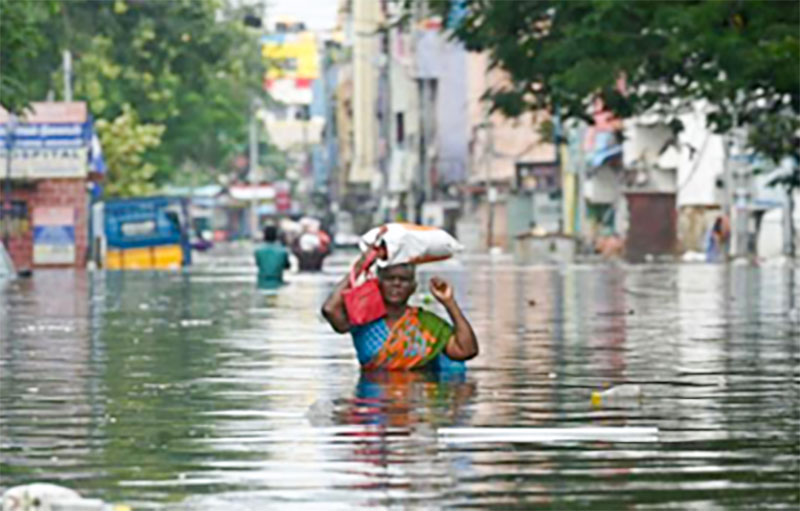
During my five years of the research in the region, I saw many hardships people face. Transportation is a major limitation. Within the embankments, there are no roads. Instead, people use boats to cross the main river multiple times and then ride bicycles or motorcycles or walk. During floods, schools are closed. Teachers and other staff who are from outside the embankments do not attend school. Healthcare facilities are lacking, so for treatment, people depend on quacks or visit the nearest government health post outside the embankment, which take many hours to reach. Pregnant women especially suffer, and many even die during childbirth. Human capital is very low.
People complain that district officers never visit villages within the embankments. In 2021, post-monsoon heavy rains resulted in massive damage in the Nepal Tarai and Bihar, badly affecting paddy ready to be harvested. Bihar’s district administration didn’t declare this flood as a disaster and the government did not provide people with relief. The government’s standard flood calendar assumes that after Durga Puja (generally in September or October) the Koshi recedes and there is no flooding. Yet in late October 2021, the region flooded and adversely impacted people. The flood took the people by surprise. They felt that climate change may have made rainfall more extreme and that the flood was a result of that effect. This example of not declaring floods underpins the prevalent rigid disaster management framework in Bihar, which does not recognise surprises. My interactions with the government’s engineering and administrative agencies highlighted that there is a total disconnect between their understanding and ground reality.
There is disconnect between understanding government’s engineering and administrative agencies and ground reality.
It is normally assumed that disasters are associated with suddenness and unpredictability. The Koshi floods within its embankments are different: the elements of surprise are few since both people and state agencies know when and where floods will occur though there may be a few exceptions. Many people in the field have an idea what the river’s main channel flow path in the monsoon months is and prepare accordingly. The tendency to prepare ahead was the case before the embankments were built but this knowledge simply did not figure into the then scheme of things regarding flood response. The statutory “standard flood calendar” and “flood operating procedures” are based on the notion of the “regularity” of the river’s floods, a notion, which, due to the impacts of climate change, is becoming increasingly unsupportable. There is no institutional recognition of this emerging constraint, however.

A farmer with his wasted paddy due to untimely floods. Source: Rahul Yaduka
Looking ahead
Effective flood risk reduction strategies broadly in the region and specifically in the lower Koshi River need reevaluation. Statutory definitions of flood disasters need to be adjusted to take into account the region’s changing ecological, social and climatic contexts. Factors such as the political-economic interests of the politician-bureaucrat-contractor nexus, electoral politics, and the epistemic dominance of the water resource department maintain policy inertia and debilitate the pursuit of tangible context-sensitive measures. The weakening of the political power of people in the Koshi lowlands, delimitation of constituencies, and the systematic stigmatization of the people living on the diyara (sand deposits) i as criminals in popular discourse are other factors at play.
Effective flood risk reduction strategies in the region need reevaluation.
To support people within the embankments in Koshi and introduce more effective flood risk mitigation efforts, the following changes needs to happen.
Relief support: Timely relief, boats, relief camps, drinking water, and medicine are key to saving lives and minimizing humanitarian loses. Improving transportation will help significantly.
Punarwas (resettlement): Most people within the embankments are dependent on agriculture for their livelihoods and are apprehensive about what livelihood they will pursue at the punarwas sites, land and farmland about 10 km from where they live. People find it impractical to commute daily between where they live and where their sources of livelihoods are. Since most young men have migrated to urban areas for work, women end up being the first responders to floods. In interviews and focused group discussions, women demanded that they be resettled on safe and stable land outside the embankments to keep them safe from the vagaries of the river.
Basic support: After the embankments were constructed, floods made kharif (summer) crop production unreliable. Thus, a formerly rice-consuming society now depends on wheat. In addition, agricultural production, is declining and support such as the timely availability of fertilisers within the embankments is essential. Farmers lack bargaining power and sell their produce at a rate far below the market price. Since agricultural output is declining and the government has not extended support for irrigation, fertilizers, or the purchase of crops, people have asked that the government stop collecting lagaan (tax) from them.
Rejuvenation of Koshi Peedit Vikas Pradhikar: In 1987, the Government of Bihar formed a committee to investigate the plight of the people within the embankments and proposed forming Koshi Peedit
Vikas Pradhikar. This organization is currently in limbo. The reactivation of the Pradhikar and implementation of the committee’s suggestions would go a long way toward improving the condition of those living within the embankments.

Difficult mobility on the diyara; Source: Rahul Yaduka
Soft approach to flood-risk management: Much of the blame for the present predicament of the Koshi region lies in flood-control technology—embankments in a heavily silt-laden and migratory river—whose efficacy was questioned before and during the conception of the project. The flood policy statement discussed in India’s parliament in 1954 did lay out the limitations of structural measures such as embankments in totally controlling floods. Subsequent reports by the Centre Water Commission, National Disaster Management Authority, Ganga Flood Control Commission, and NITI Ayog of Government of India also highlighted the need to shift towards non-structural solutions, including floodplain zoning and floodproofing. These suggestions need to be put into practice.
Conclusions
At the 1937 Patna Floods Conference, Captain G. F. Hall, the then Chief Engineer of Bihar, prophesized that the construction of embankments in the Koshi would be akin to storing a disaster whose impact would be faced by future generations . This prognosis has proven correct in the lower Koshi River region. The Koshi Flood Control Project sanctioned after the 1954 agreement between Nepal and India has not been successful in meeting its objectives. With climate change, the flows of the Koshi will face new dynamics in both the dry and the monsoon seasons. Not only will the seasonality of the Koshi’s flow will be altered but the knowledge used by formal institutions to manage flood risks will be rendered inadequate. The lived experience of people in the lower Koshi region and changing climate call for a review of past efforts at flood control and the beginning of work towards more flexible approaches across the board. Sticking to orthodox practices will be the worst form of hubris.
Notes
- In 2022, the Manch helped facilitate the formation of the People’s Commission on the Lower Koshi River Problem. Experts from India and Nepal representing the fields of ecology, hydrology, and earth science served as members of the commission.
- Baghel (2014) estimates that approximately 1.2 million people live within the embankments. The issues of displacement, compensation, and resettlement are still ongoing. When the construction of the embankments began in January 1955, 45,000 families in 380 villages in Bihar and 34 villages in Nepal were residing within the embankments. The Government of India was to provide compensation and assured resettlement in safe areas. By the end of 1973, however, 32,450 of the 45,000 families had received the first instalment of compensation for their land, 10,580 families had received the second instalment, but none had received the third and final instalment. The government provided compensation only for houses, not for farmland. People found daily commuting to resettlement sites hard. Furthermore, the allocated land became waterlogged after the embankments were constructed, forcing people to return to their original villages and live within embankments even though they had received compensation.
- Sand-covered land on the river bed that changes with flood sequences