Weathering Ecological Disruptions
We need to begin narratives about the challenges that the new but degraded local riverine ecology across the India-Nepal border pose. Local communities across the border must come together to co-produce sustainable water solutions.

Increasing Risks
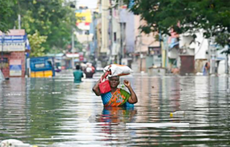
In its 2019 assessment, the Kathmandu-based International Centre for Integrated Mountain Development suggested that a rise in average global temperature of 1.5°C by 2100 would mean that the Hindu Kush Himalayan region would be warmer by around 1.8° C. In this scenario, the study continues, the glacier volume in the Himalayas would decline by 36% by 2100. Under a business-as-usual scenario for emissions, however, that loss would reach 64%. These changes are likely to deplete the base flow of many of the snow-fed rivers that originate in Nepal and join the Ganga in India. It is unlikely that changes will occur only in glaciers and that everything else will remain normal. On the contrary, the impacts of glacier loss will spread to the region’s highland-lowland interlinked ecosystems, systems on which large sections of people in Nepal, Bihar, Uttar Pradesh, West Bengal, and Bangladesh depend. It is a region with a highly dense population, the majority of whom are poor and marginalized.
The Ganga basin is not ecologically homogeneous, though scientific and popular writings tend to treat it as such. While a macro-perspective is valid for assessing the stocks and flows of the rivers in the basin, it hides the diversity among the eastern and western Ganga basins as well as among the rivers flowing from the Vindhya Range and those flowing from the north Himalayan mountain system. Three types of rivers flow to the Ganga from the Himalayan mountain system: those that originate in the Himal and are fed by snow-melt water, those in the mid-mountains, and those that originate in the Siwalik. While the latter two types of rivers are fed by monsoon rains and are not affected by changes in glaciers and snows, they are vulnerable to changes in rainfall dynamics. After flowing across the Nepal Tarai—the upper part of the Ganga plain—all three types of rivers flow into Uttar Pradesh and Bihar, where they join the Ganga River before they flow into the Bay of Bengal via the Padma and Hoogly rivers.
The provisioning, supporting, regulating, and cultural services that these rivers provide sustain the lives and livelihoods of the millions of people who live in the basin. Thus, any changes in the dynamics of river flow will have consequences, particularly on the marginal and vulnerable people who depend on the rivers. Already, in many parts of the basin, the river ecologies are not what they were fifty years ago. Over the last several decades, massive structures have been built to meet growing developmental aspirations, specifically to control floods, provide irrigation water, generate power, and improve commuting. These infrastructures have brought substantial changes to local ecosystems.
New interventions will bring more alterations and climate changes will add to an already stressed local riverine ecology. Large tracks of land, particularly in the bordering areas of Nepal and India along the Rapti, Gandak, Bagmati, Kamala, and Kosi rivers, already face high stresses as rivers are no longer free-flowing, siltation has increased, and land had been affected by seepage, inundation, and water-logging. These changes have led to the emergence of many local spatial units, each with a new ecological character different from what it generally was, say fifty years ago.
Schematic showing Nepal’s Tarai and North Bihar along the Bagmati River (Source: Dixit,et al 2007)
Newly Created Ecology
Some of the newly created ecological conditions are as follows:
- Silted areas: These are land affected by deposition of silt ranging from 1 ft to 10 ft in depth. The deposition has made the soil infertile and partially embedded houses in silt.
- Waterlogged areas: These are areas outside the embankments where seepage has resulted in perennially stagnant water. They are unsuitable for farming.
- Annually flooded areas within embankments: These areas face the erosion of land masses along the river within embankments. Within embankments, the rivers also change their course and gradually erode arable land.
- Eroded areas: These are land within embankments where families live and which are eroded.
- Depressed areas: These areas are land close to embankments where disrupted flows accumulate, adding to water-logging in post-monsoon months.
The emergence of new ecologies is an outcome of the mismatch between the region’s environmental and social contexts and conventional water development approaches (Dixit, 2020). Barrages, dams, and embankments were planned in isolation and built without due consideration for either riverine ecology of local livelihoods. They have altered the ecology and adversely affected the livelihoods of people in the plains generally and those on the two sides of the Indo-Nepal border particularly. These new micro-ecological conditions have altered traditional food-water relationships. Overall, degradation of the land is the end result, a fact which adds to existing challenges.
The overuse of water and inappropriate water management mechanisms have placed us on the threshold of crossing into territory where there is no hope for ecological regeneration. These changes have also divided communities into groups which share specific aspirations, and these different interests tend to collide. Even so, people are coping with the new situation despite there being almost no external support. Some people end up as low-paid migrants in cities. Because of COVID-19, however, many have been forced to return home as the informal sector in which they once worked has shrunk substantially. The number of people dependent on river ecosystem services for food and livelihood has thereby increased and they are likely to be further pushed into deprivation. As climate change progresses, their hardship will be significantly exacerbated.


Actions for Change
The following three actions can support ecological restoration:
First, it is necessary to support communities to cope with new adversities which they have not had to deal with in the past. They need new skills, inputs and extension services to improve their local produce in the new ecological setting. They need to be linked to formal institutions, too, so that support is not maladaptive.
Second, it is necessary to broaden the definition of water cooperation between Nepal and India. Past cooperative efforts have centred on large-scale projects on snow-fed rivers. A nature-based approach should serve as an entry point along the Siwalik rivers. This approach must involve communities on both sides of the border as the main actors, with the Nepali and Indian governments playing the role of facilitators. A major focus must be on maintaining environmental flow and riverine ecosystem services as well as on harnessing the resilience of local and traditional knowledge to make adaptive actions.
Third, efforts must be made to minimize disruptive interventions in rivers. This approach should be backed by a pro-river ecology narrative that guides the political economy of the river use. Pro-river ecology champions from among local communities need to lead the efforts to rejuvenate ecology and maintain natural ecosystem-dependent livelihoods. People living in the different micro-ecologies of the river basins and across national boundaries must be brought in as primary stakeholders.
Conclusion
The actions mentioned above can help in identifying ways to maintain a balanced river ecology as one of the cornerstones of sustainable development in a river basin. The proactive development and presentation of narratives of a new local riverine ecology in public discourse also need to emphasize co-exploring of solutions by communities across the Indo-Nepal border. These steps are imperative as more interventions in rivers are likely in the future as the need for commodities, goods and services increases. The threats of a degraded micro-ecology and climate change to local communities are real. They also raise questions about the grounding of theoretical concepts like the water-energy-food nexus and integrated water resource management as a new ecological context emerges.
Suggested Readings
- Chakraborty, T. et al., (2010). Kosi megafan: Historical records, geomorphology and the recent avulsion of the Kosi River, published in Quaternary International, November 2010.
- Devkota L., Giri S., Crosato A., Baral B. (2018). Impact of Kosi barrage and embankments on river morphology and dynamics, Seventh International Conference and Exhibition on Water Resource and Renewable Energy Development in Asia, 13-15 March 2018, Ariyana Convention Centre, Danang, Vietnam.
- Devkota, L.D. and Gyawali, D.R. (2015). Impacts of climate change on hydrological regime and water resources management of the Kosi River Basin, Nepal, Published in Journal of Hydrology: Regional Studies Volume 4, Part B, September 2015, Pages 502-515.
- Dixit A, et al. 2007) Flood Disaster Impacts and Responses in Nepal Tarai’s Marginalised Basins in (2007) Working with the Winds of Change Toward Strategies for Responding to the Risks Associated with Climate Change and other Hazards: Marcus Moench and Ajaya Dixit (eds) ProVention Consortium; Institute for Social and Environmental Transition-International; Institute for Social and Environmental Transition-Nepal.
- Dixit, A.; Shukla, A.; Wajih, S., and Singh, B. (2018). Fragility, Complexity and Development: A Political Economic Analysis of Kosi River basin. 9. GEAG (2019) Multi-layered and multi stage dialogue process in Kosi basin, Unpublished Reports, conducted under the TAF supported Project, January 2019, Supaul, Bihar
- Doody TM, Cuddy SM, Bhatta LD (2016) Connecting flow and ecology in Nepal: current state of knowledge for the Kosi Basin. Sustainable Development Investment Portfolio (SDIP) Project. CSIRO, Australia. 194 pages.
- Govt of Bihar, (2020), Bihar Economic survey Report 2019-2020 http://finance.bih.nic.in/Reports/EconomicSurvey-2020-EN.pd
- Mishra, DK (2008a). Trapped between the devil and deep waters. Dehradun and Delhi: People’s Science Institute and South Asia Network on Dams, Rivers, and People (SANDRP).
- Mishra, DK (2008b). The Kosi and the embankment story. Economic and Political Weekly, November 15, 2008.
- Mishra, DK (2008c). Bihar floods: The inevitable has happened. Economic and Political Weekly, September 6, 2008. 13. https://krishijagran.com/news/bihar-krishi-roadmap-2017-2022-launched.
- Neupane, N.; Murthy, M.S.; Rasul, G.; Wahid, S.; Shrestha, A.B.; Uddin, K. (2013): Integrated biophysical and socioeconomic model for adaptation to climate change for agriculture and water in the Kosi Basin. A Handbook of Climate Change Adaptation; Springer: Berlin, Germany; pp. 123.
- Omaid Najmuddin, Golam Rasul, Abid Hussain, David Molden, Shahriar Wahid and Bijan Debnath (2018). Low Water Productivity for Rice in Bihar, India A Critical Analysis, Water 2018, 10, 1082; doi:10.3390/w10081082, https://www.mdpi.com/journal/water
- Wester, A. Mishra, A. Mukherji, A. B. Shrestha (eds) (2019) The Hindu Kush Himalaya Assessment— Mountains, Climate Change, Sustainability and People Springer Nature Switzerland AG, Cham.