Rethinking the Commons
Urban planners and architects need to see rural and urban not in silos, but as integrated eco-systems.

Commons are under threat. In India, and elsewhere in South Asia, communities collectively managed natural resources like lakes, wetlands, ponds, grazing lands and pastures. These commons played an important role in sustaining local livelihoods. In particular, they were important for small and marginal farmers or landless households who did not have much by way of private assets. Water commons like lakes, ponds, and wetlands also performed several ecological functions; for instance, in supporting biodiversity and recharging aquifers. These commons also provided contexts for the study of the relationship between the ecological, institutional and technological dimensions of natural resource use; for instance, a tank comprised technology or artifacts for the storage and release of water, while being supported by institutions – the norms, rules and codes of conduct surrounding tank maintenance and use. As socio-technical constructs, these tanks embody a water heritage. Stepwells, such as those found in several parts of North-West and West India were also architectural marvels.


Waste dumping on the banks of the Deepor Beel (Photo: Vishal Narain)
These commons are increasingly under threat. Local encroachment of commons by village residents, in particular, local elite has been known for a long time. In more recent years, however, threats have come from urban expansion. Increasingly, commons are being engulfed by the city either through state efforts at urban expansion or by being encroached through real estate. This has grave implications for equity; commons-dependent livelihoods are compromised and jeopardized in the process. This is an expression of an urban political ecology that assumes the city to be more important than the rural; the infrastructure needs of the cities receive priority over those of surrounding rural and per-urban spaces.
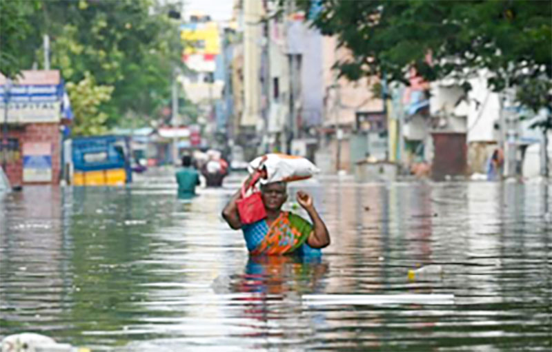
However, equally serious are the environmental implications of this process. The increased incidence of urban flooding seen in major cities of India and Nepal is the result of the combined effects of climate change- the incidence of high intensity rainfall over short spurts of time – combined with the loss of water bodies and drainage routes for water accompanying concretization. Capitalist modes of production and appropriation of wealth – exemplified for instance by the growth of real estate that has fueled urban expansion in such Indian cities as Gurgaon, Bangalore, Chennai and Hyderabad – pay little attention to how the ecological foot-print of urbanization is borne. Cities are considered to be engines of growth. Cities have a metabolism that consumes land and water resources from the peripheries and transforms that into amenities and infrastructure. This ecological foot-print is increasingly being borne by the village commons.
Site for “Global model village” on the banks of the Deepor Beel (Photo: Vishal Narain)
State authorities often allocate the lands underlying commons such as wetlands to educational institutions and NGOs. Such commons are seen simply as a source of natural resources for cities, or as sinks for their wastes, overlooking the multiple functions that are performed by them. For instance, in the North-East Indian city of Guwahati, the Deepor Beel, a wetland, is officially used as a dumping ground for the wastes of the city by the Municipal Corporation of Guwahati (picture 1). Much of the land around it has been allocated for alternative uses, including, paradoxically, for one “Global Model Village (picture 2)”. A railroad has been constructed, cutting through it, disturbing the navigation routes of people who navigate the beel to maintain links with the mainland. The beel is home to the Greater Adjutant Stork, the most endangered stork in the world today: its population around the beel is under threat because of the waste dumping activities. Originally the beel was about 40 sq. km in area, which has shrunk to about 4 sq. km .[1] This is on account of encroachment, changing land use, pollution and overexploitation of the wetland.


Common land in the city (Photo: Vishal Narain)
The beel is an important source of livelihood for fishing and for irrigation for people who live around it. Interviews with the beel dependent population reveal a decline in the diversity and quantity of fish catch. The word “deep” means elephant in Assamese, and the beel gets its name from the elephants who frequent it for their feed of fox-nut. This diversity of multiple functions that are performed by such commons is ignored by state agencies as they allocate the land underlying such commons to alternative uses.
At the same time, the complexity of interactions and processes around the commons is increasing. Historically, such commons existed with clearly demarcated boundaries of space and users. Studies of such commons managed collectively by communities through well-designed institutions or “rules in use” provided a counter-narrative to the narratives of state-owned or privatized commons to avert the tragedy of the commons. In the nineties, these provided a rationale for policies and measures to promote user participation in natural resource management. These commons were studied largely in agrarian contexts, with a focus on design principles; clearly demarcated resource and user boundaries were considered as an important feature shaping their sustainability.


Locals collecting wood from the common land (Photo: Vishal Narain)
The current process of urban expansion however means that rural and urban boundaries are blurring. ‘Rural” and “urban” no longer exist as concrete, clearly demarcated areas. Rural and urban instead represent a continuum. This makes a classification of commons as rural or urban problematic. For instance, I live in Gurgaon, considered India’s millennium city. As I leave the main gate of my residential colony, 200 m on either side, I enter a rural settlement – a village called Samaspur on one side and Tigra on the other. From the balcony of my house, I can see a patch of common land that is being gradually cleared – perhaps another school, guest house or gated colony will come up there (picture 3). But people from the two surrounding villages still frequent it to collect fodder and fuelwood or to graze their livestock (picture 4). After the rains, when water is flooded in the small depressions in this patch of land, it quenches the thirst of the village livestock. Village youth play football every evening in a patch of land that has been cleared to make way for a football field. Officially, both these villages are under the jurisdiction of the Municipal Corporation of Gurgaon. So how would we classify this common? As a rural common or an urban common? During the pandemic days, I have watched village folk come to this patch of land to chop fuelwood and collect fodder. While urban residents like I had the privilege of home delivery, there is no home delivery of fuelwood, fodder and water for village folk! As this patch of land gets cleared, and new construction activity starts, local residents may have to explore alternative sources of fodder and fuelwood or take their livestock further afar to graze.
Altering the status quo asks us to raise questions of politics and planning in urban expansion. We should challenge the implicit biases in our development processes that prioritize the needs of the urban over the rural. In India, many civil society organizations, NGOs and activists are engaged in advocacy in protecting the water commons as lakes and wetlands. The measures are necessary but are reactive. A proactive approach to education, research and planning for urban expansion should challenge the urban-rural dichotomy in development. Urban planners and architects need to see rural and urban not in silos, but as integrated eco-systems. We need scientific studies of the carrying capacity of cities and of urban metabolism to inform urban planning approaches.
Finally, the potential of the water commons as a means to building disaster resilience and reducing climate risk needs greater appreciation. Eco-system services-based approaches to disaster resilience emphasize the regulatory functions of eco-systems. Protecting wetlands and mangroves is not only to be seen as a means to an end of supporting the dependent livelihoods but also as an end in itself. Maintaining the integrity of eco-systems can serve as a strong buffer against climate shocks, disasters and extreme events. If this thinking had prevailed with the earlier generation of urban planners and policy-makers the unprecedented flooding seen in such cities as Bangalore and Chennai could have been avoided.
Notes:
[1] https://www.conservationindia.org/gallery/losing-their-home-greater-adjutants-in-assam, accessed on November 26, 2021